- 1 - Besisahar to Khudi: Most People Walk Further to Work
- 2 - Who Says Trekking in Nepal Has to Involve Lots of Walking?
- 3 - Conquering the Annapurna Circuit’s First Hill
- 4 - Trek to Jagat and a Rant Against Guides on the Annapurna Circuit
- 5 - Jagat to Tal: Our First Real Day of Trekking
- 6 - Tal to Chame: Falling into a Trekking Routine
- 7 - Chame to Pisang: Just Takin’ the Goat for a Walk
- 8 - A Well-Deserved Day Off in Upper Pisang
- 9 - Pisang to Ngawal: A Hard Climb to Beautiful Views
- 10 - Drinking Yak Sewage in Ngawal
- 11 - Arriving In Manang…Two Weeks Later Than Most
- 12 - Trekking On Our Day Off From Trekking in Manang
- 13 - Annoying Trekker Abuses Friendly Guesthouse Owner
The next morning we ate a leisurely breakfast, content in the knowledge that we didn’t have to set out on a day of hiking. We were taking the day off to help us adjust to the altitude. OK, so we were already completely adjusted thanks to our slow pace and our having taken a day off for ‘altitude acclimatization’ in each of our last two stops. But no one needs to know that. Let’s just say we were just being extra cautious. Altitude sickness can be dangerous.
I know you’re thinking we just sat around all day doing nothing, but no. We did more walking. People who spend a day in Manang for altitude adjustment do two things: they watch a movie in the only theaters along the Annapurna Circuit and they go on an ‘acclimatization hike.’ The theaters were out of the question. I refuse to lose two hours of my life watching Shia LaBeouf pretend to fight off a bunch of computer animations and the other movies showing in town were even less appealing.
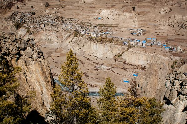
The town of Manang seen from above. This is how far I ended up climbing on my supposed day off.
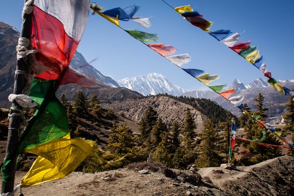
That left the acclimatization hikes. The most popular one takes you a few hundred meters up the side of the valley to a little temple where an ancient entrepreneur holy man sits and takes trekkers’ money blesses trekkers to ensure good luck on their upcoming journey over the pass. Trekkers report returning from the temple feeling spiritually refreshed and uplifted (hint: that’s probably altitude sickness!). I’m sure you’ve guessed this wasn’t the hike for us.
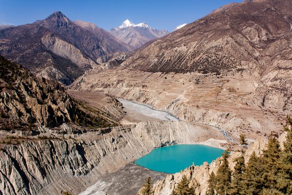
Instead, we decided to climb toward a glacier on the other side of the valley. Once up a ways, we would get great views of the glacier, of a turquoise lake filled with water from the glacier and of the whole Manang valley. This sounded much more appealing than some old guy on a hill. It also sounded much more exhausting, but we don’t mind a bit of exertion if there is a payoff at the end.
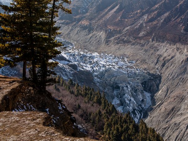
The glacier. Not worth the effort on its own, but combined with the other views (like the one of Manang above)…
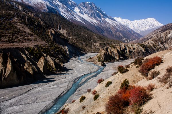
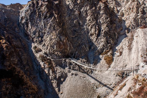
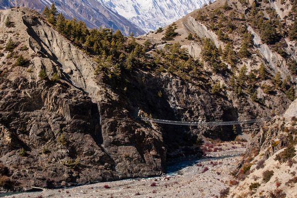
The town of Manang does not sit at the bottom of the valley, but on a shelf at the top of a cliff 50 meters or so above the river. To get to the other side of the valley, we first had to scramble down to the river and the bridge across. Then we started our ascent to the rim overlooking the turquoise lake. From there we could snap a few photos of the lake, but the drop down to the water was far to steep to actually get near it.
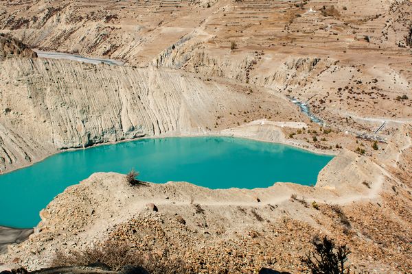
That’s the rim of the lake. And, yes, the water really was that color.
More accurately, I snapped a few photos of the lake, but couldn’t get near it. The other two were still far below and moving slower than ever. The guy who had been feeling sick the whole trek was doing even worse and his body was not happy with his decision to leave his bed, let alone climb a steep hillside. It wasn’t long before they made the decision to turn around and head back to the hotel. I continued on my own.
By this point in the trek, I had adjusted to the altitude and the constant exercise. I was in the best shape of my life. I realize that’s not an especially high bar, but somehow, I had actually become fitter than most of the people around me. I climbed quickly and before I knew it, I had reached a little plateau. I even passed a number of groups along the way. I also encountered a few groups heading back down. How early had they set out?
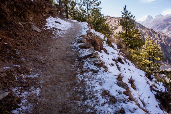
I also encountered the first snow on the trek, but just in shaded areas.
As is always the case, there was another hill behind the one I had just climbed and, of course, another behind that one and then another and another. I climbed one more of those hills and found an abandoned village. It wasn’t permanently abandoned, just temporarily. We came across several of these higher-altitude villages on the trek. In the summer months, local farmers live there and farm the surrounding fields or let their yak graze. When winter comes, they move down into the valleys until the weather warms up again. We were trekking in November, so all of these villages were empty.
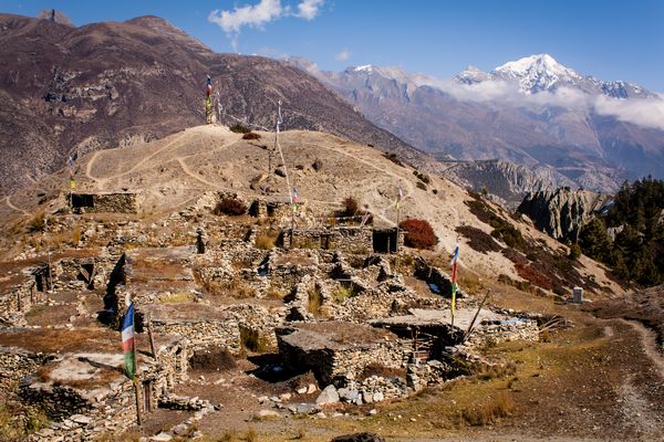
The village
I took a bunch of photos of the village and the valley below. I noticed a group of trekkers far above me, just below the snow line and the point where the mountain turned completely to rock. I could tell the views from up there were amazing, but the ones I was enjoying were good enough for me. I had climbed four to five hundred meters already. That was plenty for what was supposedly a day off. I headed back down to rejoin the other two at our hotel. They were playing cards, as usual, and had even found another person to join them.
Some more views from the village. That’s Tilicho Mountain in the background, my destination for the next day.
That other person was an Irish woman. A bout of altitude sickness had kept her in Manang far longer than anyone who doesn’t live or work there should ever stay. Rather than heading back down the mountain, she had decided to wait it out and hope it passes. She had been wanting to complete this trek for a long time and did not want to lose her one opportunity. Unfortunately, she had hired a guide (and a very annoying one, I would find out a few days later), so she was on a strict time schedule. Every day in Manang was one less day she had on the other side of the pass, should she ever make it across.
The view of the little lake from above and the valley that heads toward Thorong Lo Pass
I definitely felt bad for her. For about ten minutes. That was all the time it took to realize just how much she enjoyed whining; it was also enough time to begin doubting the whole story. Ok, that’s not entirely fair. She was definitely suffering from altitude sickness; she was also definitely playing it up for sympathy. Every time I heard the story again (and there were many times) she had added a few ailments and hardships.
As for the other invalid, the German, he was not feeling any better and doubted he would be ready for more trekking the next morning. I had no intention of spending another day in Manang and listening to more Irish-accented sob stories (although I was curious what other symptoms or diseases might develop overnight), so I made the decision to set out the next day, whether the Germans were going or not.
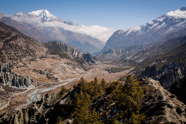
The view back down the valley where we came from the previous day.
I learned the next morning they were not, so we split up and I was on my own for the first time on the trek. Most people leave Manang and head further up the valley to begin the ascent to the 5400 meter high Thorong Lo pass, but I decided to make a side trip up a different valley to Tilicho Lake.
The world’s highest lake—according to the Nepalese, but no one else—lies at an altitude of 4900 meters, which means a lot of tough climbing and a detour of several days. It had better be as beautiful as everyone was saying. Even if it was hideous, at the very least it would get me used to altitudes over 4500 meters. I knew this would make the climb over the pass a few days later a tiny bit easier (spoiler alert: it still sucked—a lot.).
The valley that heads up toward Tilicho Lake
The path to Tilicho Lake Base Camp at 4100 meters, my stop for the night, was the most difficult section of the entire trek. At least the trail I chose was difficult. There were two options. The first was the high trail, billed as ‘much safer,’ but involving a climb of over 400 meters and a subsequent descent of those same 400 meters. It made this climb to avoid several landslide areas. The second option involved no such climb, but cut directly through the landslide zones and was thus billed as ‘more risky.’ 400 meters? I’ll risk a landslide.
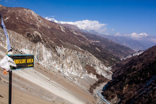
Just in case the steep slopes of loose rocks aren’t enough to figure it out, these signs mark the landslide areas
And I wasn’t alone. Everyone I encountered at the base camp that evening had taken the lower path, except for one Hungarian guy. He arrived several hours after everyone else and was seriously regretting his decision. I’m sure seeing us ‘lower path people’ in one piece and not under a pile of rocks at the bottom of the valley contributed greatly to his regret.
The path through the landslide areas
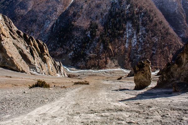
And the view down toward the river.
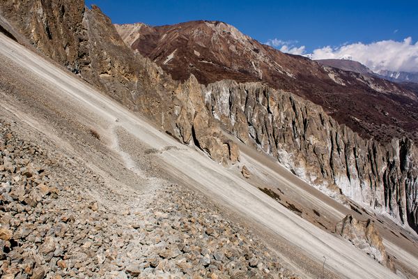
It wasn’t the threat of a landslide that made the lower path difficult, though. It was the path itself. It was very narrow and made up of loose dirt and rocks. Several sections were extremely steep. I had always thought the trekking poles (cheap ski poles rebranded and sold for a higher price) many people were using to help them walk were kind of pointless, but I have to admit, for this one section, I was wishing I had some. Without them, I had to crawl up and down a few of the steepest inclines on all fours to keep from sliding down the mountain.
One of those steep sections
And another one. The path basically heads straight up after the bridge.
It was a beautiful section, though and the weather was perfect once again. Thanks to my decision to take the lower path, there weren’t too many changes in altitude either, so I thoroughly enjoyed the day. I also moved much faster than any day previously. The relatively level path helped, but leaving the German anchors behind helped more (I wrote that for their benefit—I actually loved that they were happy to move even slower than me). Not only was I able to keep up with everyone else, I actually passed them and ended up at Tilicho basecamp in the early afternoon.
Series continued in part 13: Annoying Trekker Abuses Friendly Guesthouse Owner
It’s a beautiful region and sounds like you really enjoyed it. At my age I’ll never get there, so your account is good for me. It’s nice to get away from the crowds too, isn’t it 🙂
Definitely. The relative solitude was my favorite aspect of the trek (apart from the scenery, of course). Unfortunately, with the road they were building (and have probably completed by now), I’m guessing the Annapurna Circuit is much more overrun with people, and worse, with noisy jeeps and motorbikes. Hopefully a new trekking route will crop up to take its place.
Daniel McBane!
WOW! Great Story! Really enjoyed this article. Unbelievable place. I’m planning to go Nepal for my next trip. This article helped me lot before planning. Photos are very good with magnificent shot.
Thanks for sharing with us.
Srimanta Ghosh
Thank you! I hope you have a great time in Nepal and you come away with some great shots yourself.
What a great read mate, I am heading to Nepal in March, really looking forward to doing something like this!
Thanks again, this gave me lots of insights about my upcoming travels 🙂
Thanks! I’m glad you found something useful here. I definitely recommend trekking in Nepal if you get the chance. March is the beginning of the second high season, so it’s a pretty good time for it.
Hello Daniel,
thanks for the great report. I really like your pictures (especially the colours). May I ask what camera and which lenses did you take (and how many spare batteries). I will be doing the trek next Feb. and plan on taking the A7 with the Kit zoom and a canon 50 mm lens.
Have a good day
Andreas
Thank you! When I did this trek, I was using a Conon EOS 450D with three lenses: a 50mm 1.8, a 28mm 1.8 and the kit lens.
I’m also using a Sony A7 now and would love to do the trek again with this camera (or even better, the mark II or the A7RII). I would definitely end up with so many more good photos using a Sony (I deleted hundreds of crappy photos after the trek). I would also have a lighter backpack.
I only had one spare battery with the Canon, but with the A7 I would probably take 3 or 4. Most guesthouses have outlets in the room until you get to the higher elevations. There you will often only find outlets in the common room and many owners charge for their use (they are powered by generator, after all).
Hope you enjoy the trek and take lots of great photos!
You sound extremely negative in your writing. Wouldn’t doubt you had a great experience though; just don’t understand why you had to shit on almost everything. Did you think it was funny?
I had a great time, but there are always things that go wrong or that annoy us. Most blogs only write about the good, either to make it seem like their life is always perfect or because they get compensated. I started this blog to give a more honest account.
My best advice to you: read a different blog.
Trekking is an excellent mood booster because it combines the physiological benefits of exercise with the mental health benefits of being surrounded by nature and socialising with other people on the trail.
Manang is really wonderful and different part of Nepal. It is really great to be at here? Did you go for other trekking in Nepal?
I did not, but I do plan to go back someday soon.
Great post Dan! I think it’s the one thing my husband and I really didn’t put enough emphasis on when we started more intense trekking, was the sheer altitude acclimatization that was required on some of the bigger trekks. Great article 🙂
I really like pieces of stuff like this. A travel blogger who clicks amazing pictures and tells a great story as well. Annapurna trek is amazing as I have heard from many close peers who had been there last year. Anyways I enjoyed reading your blog.
its looks beautiful… something I have to put into my list, thanks for sharing the journey with us 🙂
The place looks awesome, something I would love to explore, thanks for sharing 🙂
The place looks beautiful… I am putting into my list 🙂
One of the informative and useful blog. Those who plan to trek around the Annapurna circuit definitely they will get more information and details from your articles. The Annapurna circuit trek is one of the renowned adventure journeys in Nepal. I look forward to seeing the next travel blog of Nepal. Good Luck.
What an incredible adventure you had! Reading about your experience of trekking on your day off from trekking in Manang has truly sparked my wanderlust. The Manang region is renowned for its stunning landscapes and captivating culture, and your account brings it to life.
It’s fascinating to learn how you made the most of your rest day by exploring the nearby trails. The decision to venture off the beaten path was certainly worth it, as you stumbled upon hidden gems that revealed the true essence of the region. The breathtaking mountain vistas, quaint villages, and encounters with locals must have made it an enriching and authentic experience.
Thank you for sharing your sweet memories in Nepal trekking.
Amazing article and photographs, thank you
Damn Daneil. This looks so amazing experience. Would you like to recommend this to those who can’t walk for long?